

How are you doing guys? I trust you enjoyed the summer we experienced in the past days if you live in the UK. I believe the heatwave is now over according to the news. If you live in different parts of the world, I trust you are well.
In my previous posts about numbering piles using Dynamo without programming knowledge (links provided below), I tried to assign a unique pile number for my piles using Dynamo where I extracted the X and Y coordinates of each pile then export the values to the spreadsheet (discussed in Part 1). And in Part 2, because I can’t work out how to sort in X-coordinate and Y-coordinate simultaneously in ascending order, I decided to sort the coordinates in Excel instead to an order that I wanted before assigning a unique pile number. After that, with the help of Dynamo, I pushed back to Revit the pile number value to the assigned Pile parameter.
Here are the links for the 2 parts to refresh you of the process.
For a challenge, I received a message from one of my blog readers asking me if it is possible to read the coordinates from Survey Point rather than Project Base Point. With his permission, see image below. Hmmmn, how will I do that? I need to do a bit of research here.

Thank you, Kieran, by the way, for purchasing a copy of my Revit-Dynamo-Power BI Guidebook and I hope you’ll find it useful. Any question, give me a shout and I’m happy to help.
For some of you who would like to see the live demonstration, please come to my Laboratory Class at BILT Eur 2018. For more details on how to purchase a ticket, please visit the BILT EUR 2018 website.
By the way, from today you can avail of 10% discount off the 3 Day Delegate rate (excluding accommodation) by clicking on the image below: Code to use will be ALLSCAN12
![]()
Anyway, back to our topic, you can achieve this using a third-party Revit plugin called “Excitech Tools”.
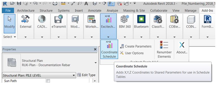
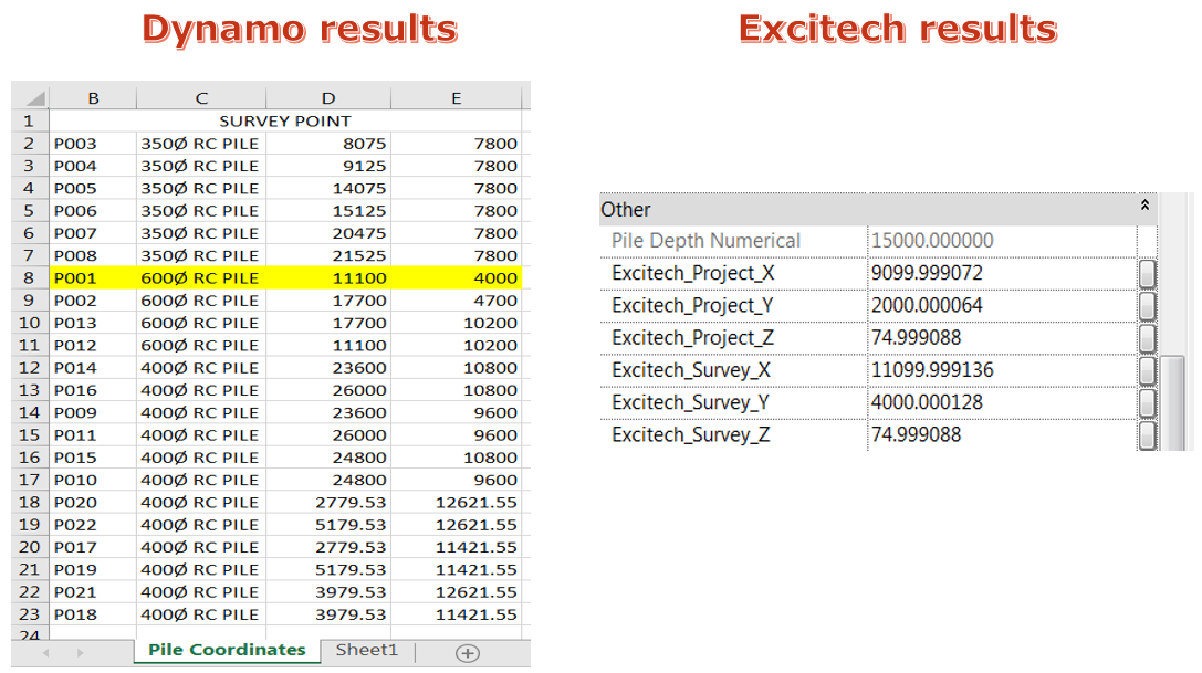
And here is the sample information you’ll get by hitting that “Coordinate Schedule” button on your “Excitech Tools” Revit plugin for pile P001 (this is the pile that we will be looking at as an example).
You’ll be provided with coordinates based on Project Base Point and Survey Point.
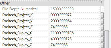
To clearly understand where these values came from, see image below.
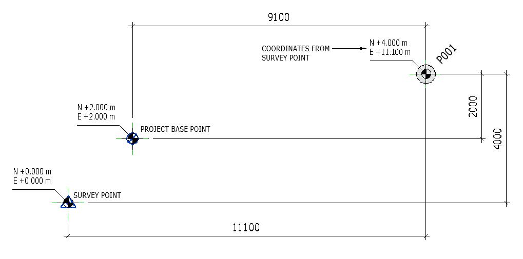
And the “Element.GetLocation” node in Dynamo will give you the coordinates relative to the Project Base Point.
In the absence of the third-party Revit plugins, such as the “Excitech Tools” Revit plugin, I will aim to publish the northing and easting coordinates of my piles based on the “Survey Point”. Take note, Survey Point not Project Base Point.
While looking for the potential solution to my problem, I came across a discussion in Dynamobim.com Forum about the same issue.
Here is the link to the discussion: https://forum.dynamobim.com/t/getting-coordinates-from-project-base-point-or-from-survey-point/7499
Somehow it gave me an idea of how I’ll achieve my goal, however, the information I’ve got from the forum wasn’t enough to solve the issue.
So, I ended up doing more research and I came across a YouTube video from Mr. David Flynn of Designtech (www.designtech.io).
See the video here: https://www.youtube.com/watch?time_continue=72&v=aIvv1oKDgeQ
Mr. David Flynn is so generous to share the script and the dataset he used in the video for us to download for free and for us to give it a try. So I downloaded the Dynamo script and had a look at it.
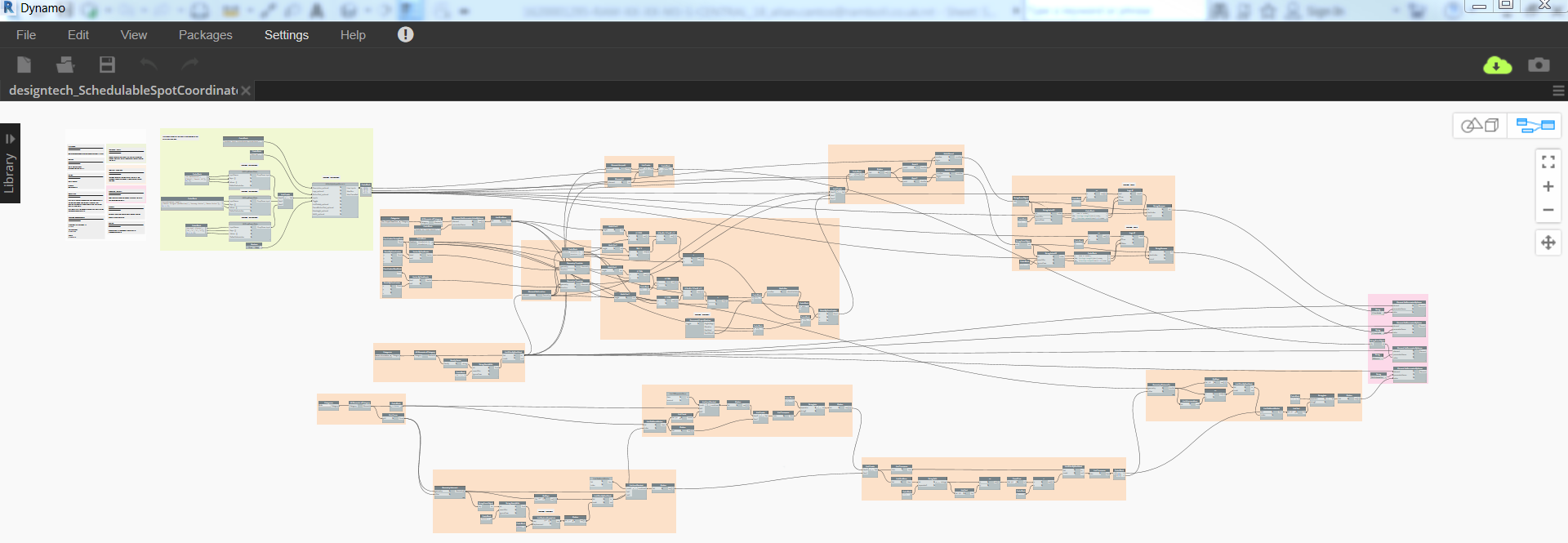
Here is what the Dynamo script looks like from Mr. David Flynn of Designtech:
Base on this, I came up with something to achieve my goal; to be able for Dynamo to provide me the pile coordinates from Survey Point instead of Project Base Point. I found some nodes that I needed to make my script work.
Here is my script looks like:
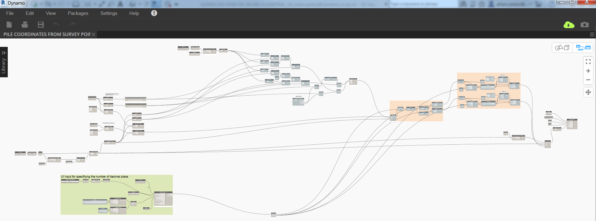
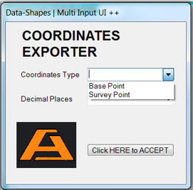
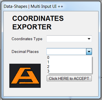
The script, which I named “COORDINATES EXPORTER” in Data-Shapes UI, was set up in a way that you can export to spreadsheet the coordinates from either Survey Point or Project Base Point (depending on the user input). Thanks to Data-Shapes Dynamo package for the UI that I used in this script.
To know more other stuff from Data-Shapes, please visit the website at https://data-shapes.net/.
And here is what you’ll see from Dynamo Player.
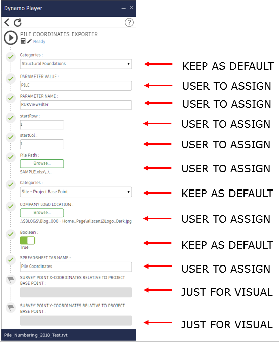
Hit play button from the Dynamo Player or hit Run if you are at the Dynamo interface, you’ll be prompted to select from the drop-down list what coordinates type you would like to reference the output coordinates.
First is to select which reference you would like your coordinates to be taken/exported.
And next, you will be able to specify the number of decimal places for the output values.
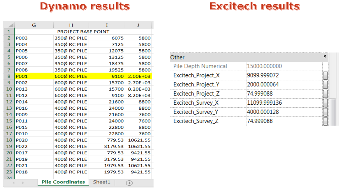
To give you the idea of the results, please see the images below.
With the Survey Point selected under coordinates type:
With the Project Base Point selected under coordinates type:
I have to revisit my script because I specifically asked to have my results to 3 decimal places but when it is zero, it’s not showing up, i.e. I’m expecting a result to be 9100.000 but the actual result gave me only 9100 (without decimal points).
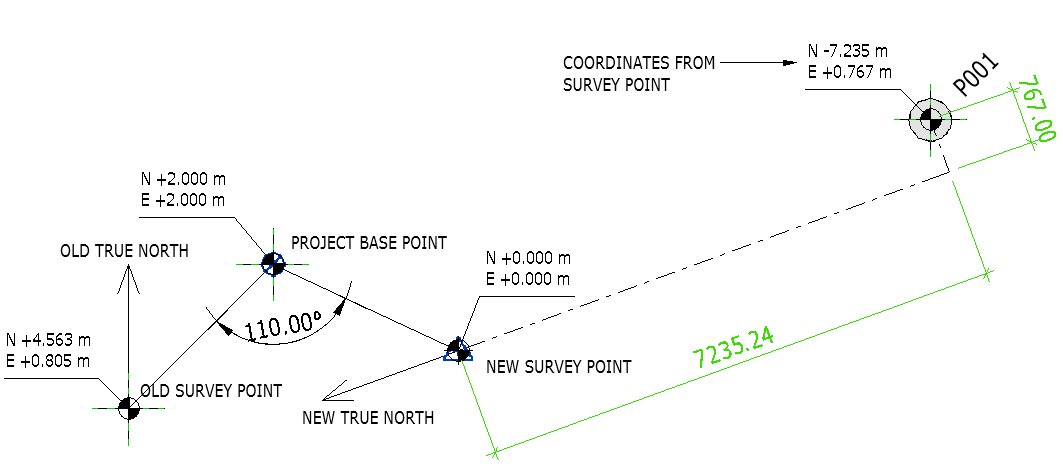
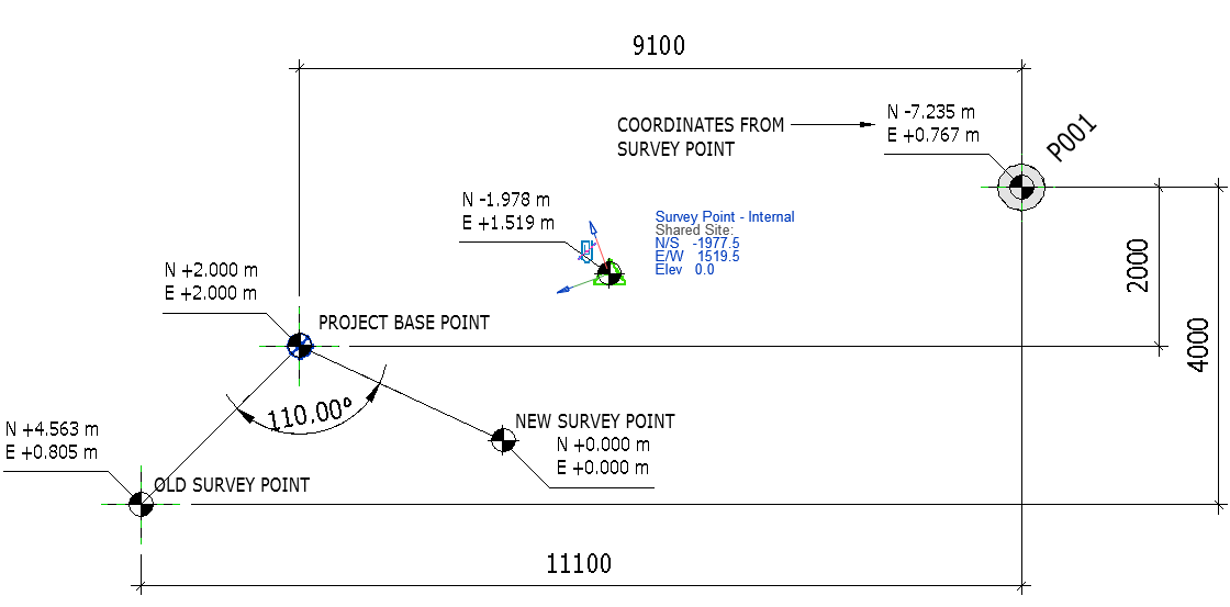
Now to complicate things, let me add some rotation angle to True North, say 110 degrees.
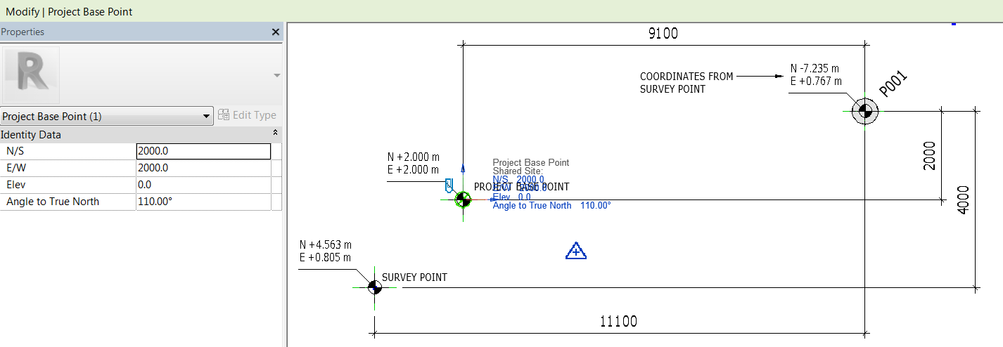
And by applying a rotation Angle to True North, the Survey Point rotates relative to the Project Base Point if it is “clipped”.
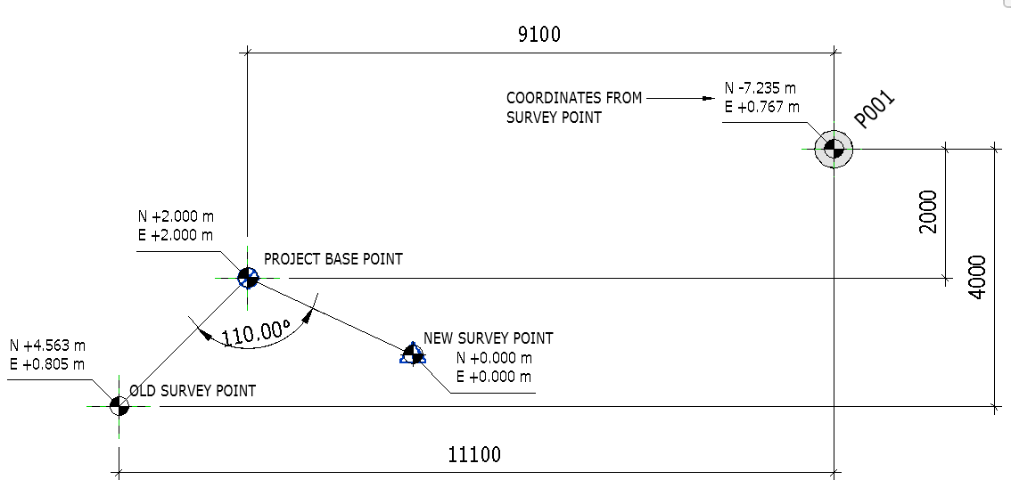
You’ll notice that the location of the new Survey Point has shifted and because of that, we have a new coordinate of pile P001 as shown above.
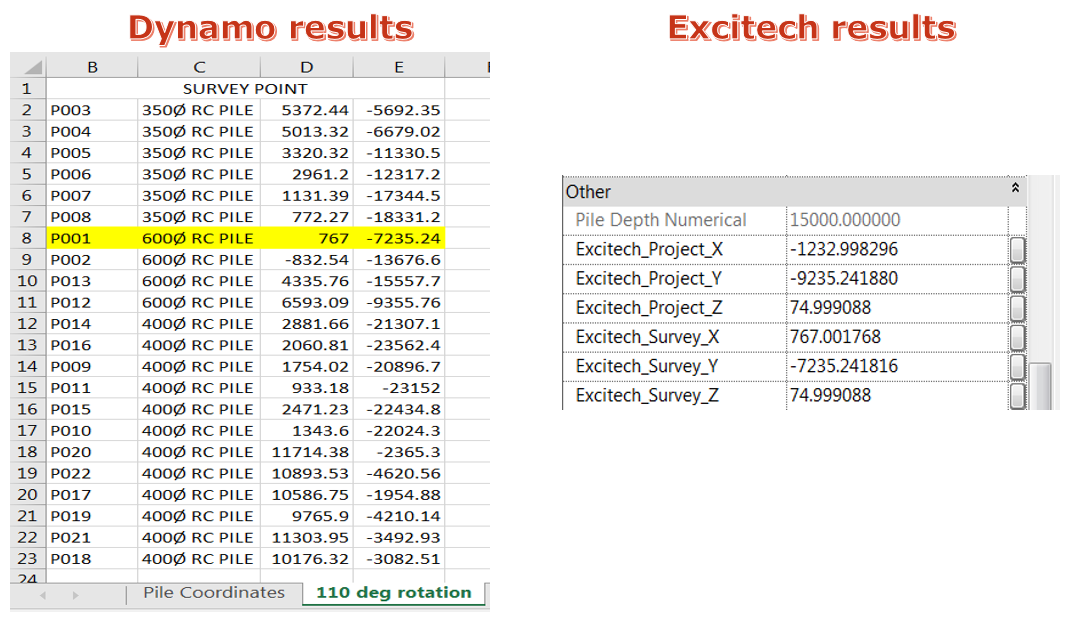
I’ll run the Dynamo script and the “Excitech Tools” Revit plugin just to compare the results. Results are shown below.
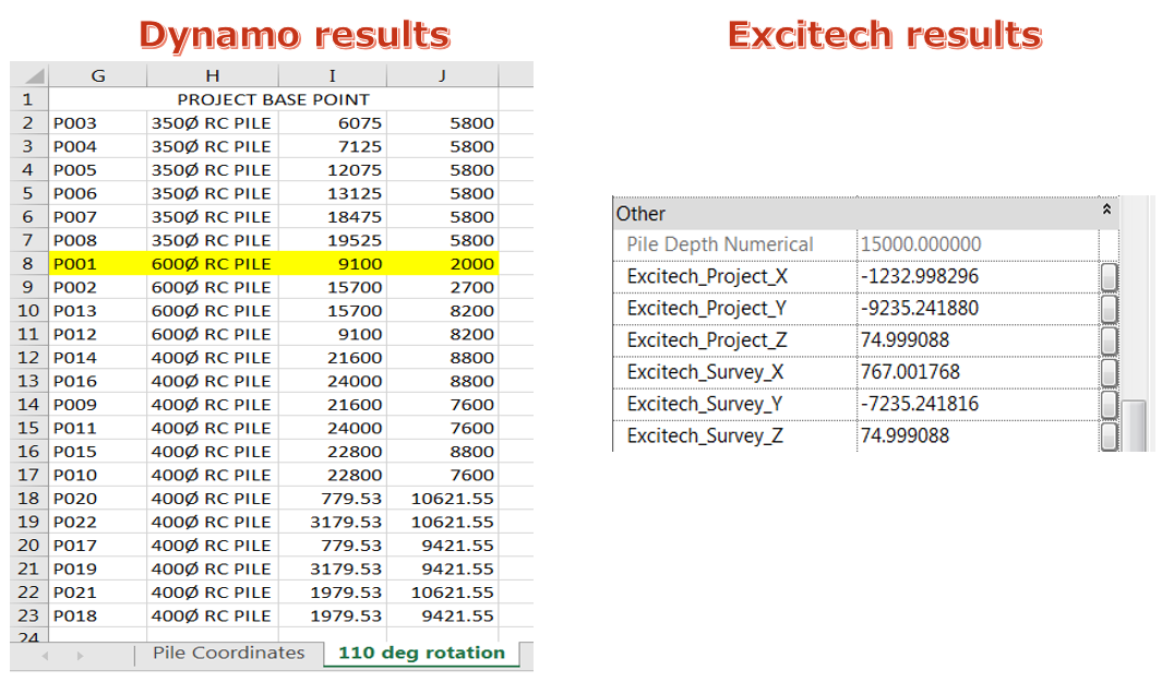
And with the Project Base Point selected under coordinates type:
Looks like my script did not take into account the rotation angle to the true north because I’ve got different results to what the “Excitech Tools” Revit plugin gave me.
To clearly understand where those “Excitech Tools” Revit plugins results came from, please see images below.
From Project Base Point:
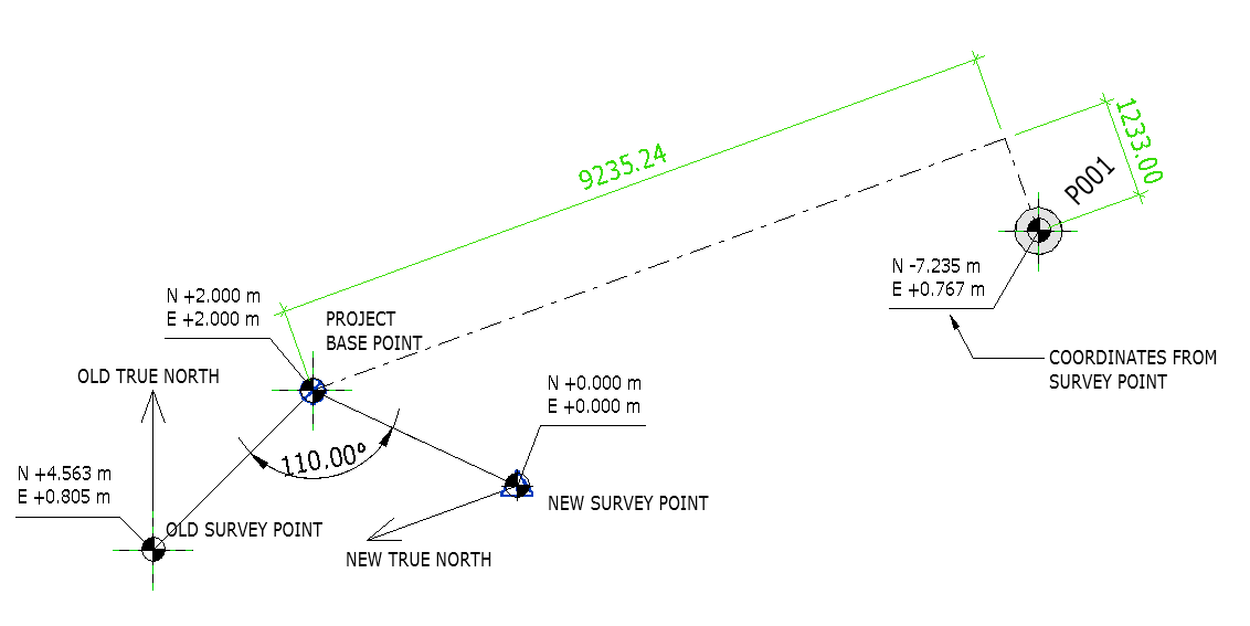
From the new location of Survey Point:
By the way, if you want to keep the Project Base Point Coordinate at (N=2 and E=2), you can re-position your Survey Point anywhere if you wish but make sure to “unclipped” it first (this should be the agreed shared coordinates for all disciplines).
If you want to give it a try, please fill up a few details below and you will receive the download link.
Some of the nodes can be combined using the code block, however, to easily understand what is the node doing/required, I tried my best to use the proper node instead.
I welcome your comments, questions, corrections and additional information relating to this article. If you know a better way, please leave your comment, by all means, let me know.
Enjoy!
Cheers,
Allan Cantos
It’s probably too long a lapse, since your post, for this to be meaningful now. However, I found the whole Revit scheme of the coordinate systems a bit of a mess. It is worth remembering that there is also the Revit origin point and that tripped me up, particulalrly when entering topsurface levels! The lesson there was, to be safe, set the SP to the same as the internal origin. If we are doing any coordinate transformations, we must remember to be aware if the internal origin is where we think it is. It may not alway affect what we’re doing, but it can.
I made a little solution, primarily for piles, (needs tidying up a little) where I define shared coordinates for PB x and y and elevation, and SP east, north and elevation. These are attcahed to any catrgories one likes (Foundations, columns etc.) within the project, then a Dynamo graph populates these instance values, and they can then be scheduled. I also added pile load and Mark for good measure.
The solution is a little messy with Dynamo, so I am now trying to decipher whether I can streamline all this with an add-in, whcih I can write in C#. The process of managing the shared coordinates is the tricky bit in this. The coodinate transformation part would be relatively easy.